By the County Groundwater Atlas team, Minnesota DNR
The Houston County Groundwater Atlas, produced by the Minnesota Department of Natural Resources (DNR) Groundwater Atlas Program, is now available for download and use, including Geographic Information System (GIS) files. Commonly referred to as Part B, it is the second atlas in a two-part series, building on the contents of Part A, the Geologic Atlas of Houston County produced by the Minnesota Geological Survey (MGS).
An overview
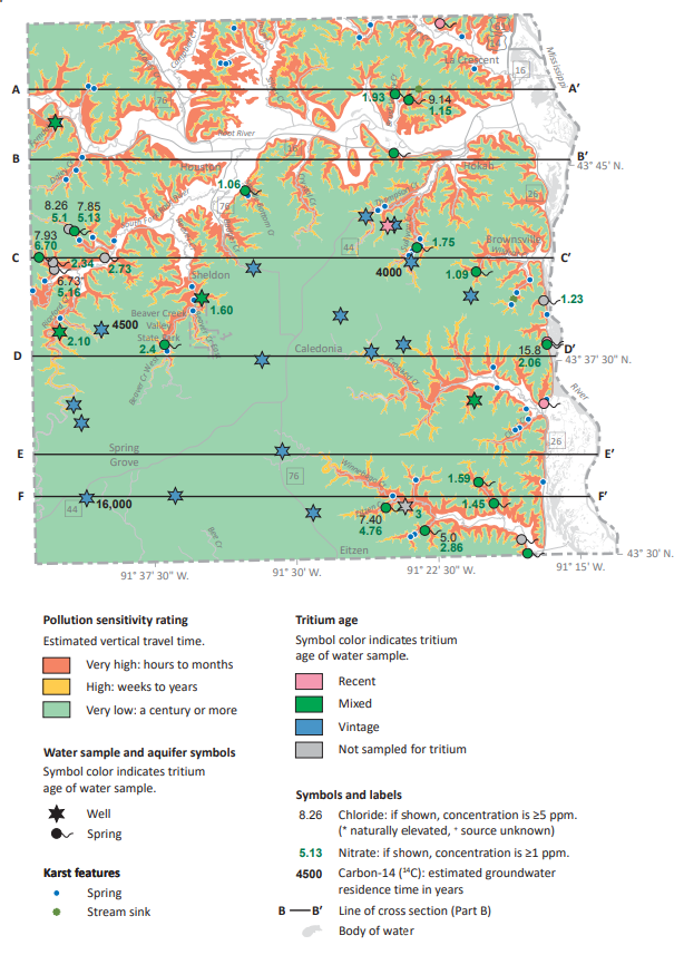
Houston County is in southeast Minnesota. Its land use is dominated by a mix of agricultural croplands, forest, and small towns. Its underlying geology influences land usage, with agricultural cropland common on the Upper Carbonate Plateau, the Prairie du Chien Plateau, and in valley bottoms. Much of the county is a karst terrain formed by precipitation and groundwater dissolving underlying carbonate sedimentary rock. Karst provides rapid water movement between the land surface and underlying aquifers, increasing their pollution sensitivity. Rapid recharge can occur in aquifers above the St. Lawrence aquitard or where aquitards are not present, such as within deeply incised valleys.
Pollution sensitivity ratings were developed for aquifers using a combination of tritium and carbon-14 data for residence time and the inorganic chemicals chloride and nitrate. Human-caused occurrences of chloride and nitrate are relatively widespread in the water-table aquifer, comprised of the Prairie du Chien and Jordan aquifers in upland settings and the sand and gravel aquifer in lowland valley settings. Chloride and nitrate are relatively widespread in shallow aquifers, especially in wells completed above the St. Lawrence aquitard. Springs, not commonly used as sources of water, have elevated levels of both chloride and nitrate. A portion of the water emanating from springs is anthropogenically impacted water that mixes with older water.
Below the St. Lawrence aquitard, groundwater shows long residence times and less human-influenced contamination. Wells completed in aquifers below the St. Lawrence can provide groundwater unimpacted by human activities if properly installed according to the Minnesota Well Code.
Pollution sensitivity of the Lone Rock aquifer (Figure 27 from atlas). Sensitivity is very low over much of the county but increases to high and very high near valley edges where the St. Lawrence aquitard is thin or absent. High sensitivity is delineated where the St. Lawrence aquitard is the only bedrock unit above the Lone Rock. Very high sensitivity is delineated where there are no overlying bedrock units.
Access the atlas
The Houston County Groundwater Atlas is available:
- Online
- The report (PDF) is available in PDF format.
- Maps of the water chemistry (PDF) and hydrogeologic cross section (PDF) plates are also available.
- GIS files, including the associated metadata and an ArcGIS Pro project, can be downloaded.
- In print
- Copies of the complete atlas (report and plates) can be purchased online from OceanGrafix.
Watch the workshop
In late February, staff from the Groundwater Atlas Program and MGS traveled to Houston County to present their findings and share practical applications of atlas information. The three-hour workshop, held in partnership with the county, was offered as a hybrid event, and a recording will be available on YouTube soon. For easier navigation, the video will include marked chapters on the geologic atlas, the groundwater atlas, and atlas use exercises.
If you’d like to be notified once the workshop video is posted, or if you have questions about the Part B atlas, please email the County Groundwater Atlas team. More information about the program and links to other county atlases are available on the DNR website.
Partial funding for this project was provided by the Minnesota Environment and Natural Resources Trust Fund as recommended by the Legislative-Citizen Commission on Minnesota Resources and by the Clean Water Fund, which receives 33% of the sales tax revenue from the Clean Water, Land and Legacy Amendment, approved by voters in November 2008.
MGWA is committed to developing a just, equitable, and inclusive groundwater community. Click on the button below to read MGWA’s full diversity statement.
 RSS - Posts
You must be logged in to post a comment.